Glossing Over Acronyms
Has all the mumbo jumbo acronyms got you down. DVRPC, PENNDOT, SAFETEA-LU, TE, TIP MUTCD what does it all mean? Never fear we now have put up a glossary to help you sift through it all. So you can request that EIS through your MPO for that next big highway project in the TIP.
http://www.bicyclecoalition.org/Bicycle_Coalition_Glossary.html

This is the legacy blog of the Bicycle Coalition of Greater Philadelphia. It is an archive of posts from 2003 to 2014. Making your ride better since 1972. https://www.bicyclecoalition.org
Wednesday, November 30, 2005
Wednesday, November 23, 2005
New Trail Openings in Montgomery County
New Trail Openings in Montgomery County
December 6, 2005
Audubon Loop through Mill Grove Estate- 11:30 AM Pawlings Road Parking Lot
Pottstown Segment of the Schuylkill River Trail 10 AM Riverfront Park
A small section of the Wissahickon Trail which effectively extends the Forbidden Drive path to Morris Arboretum is now open
December 6, 2005
Audubon Loop through Mill Grove Estate- 11:30 AM Pawlings Road Parking Lot
Pottstown Segment of the Schuylkill River Trail 10 AM Riverfront Park
A small section of the Wissahickon Trail which effectively extends the Forbidden Drive path to Morris Arboretum is now open
Minutes to SE PA Bicycle Issues Task Force
Minutes to the September SE PA Bicycle Issues Task Force Meeting
Are available here http://www.dvrpc.org/about/agenda/sepbitf/pdf/Minutes2005-09.pdf
Are available here http://www.dvrpc.org/about/agenda/sepbitf/pdf/Minutes2005-09.pdf
Friday, November 18, 2005
Bicycle Coalition Works With Google Maps
Bicycle Coalition Works With Google Maps
We have posted two maps that overlay data over Google Maps "Bicycle Coalition GMAPS" if you will. The first is a map of bike lanes (red lines) and major multi-use trails (blue lines) in the region. The second is a compilation of Bicycle Coalition Commuter routes.
Bike Lanes and Trails
Commuter Routes
These maps are a precurser to a much more ambitious project. We have partnered with several bicycle advocacy organizations and individuals across the country to create an easy to implement bicycle route planner which will allow you to type in your start point and end point a get a bicycle route. There are two examples in this country Bike Metro in the Los Angeles Area and prototype bicycle trip planner for Portland Oregon.
Saturday, November 12, 2005
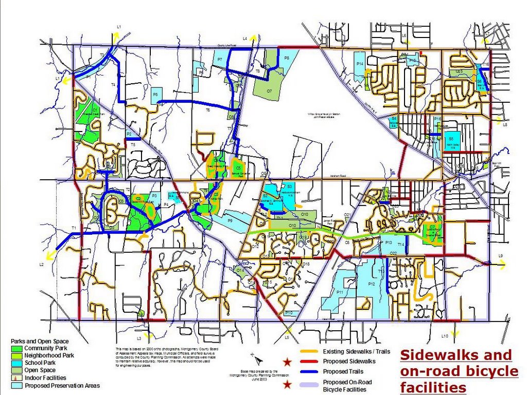
Horsham Township Bike Ped Plan
Horsham Township Proposed Bicycle and Pedestrian Facilities
This map show the townships existing and proposed bike lanes/shoulders (lavender shading), sidewalks (red) and multi-use paths (dark blue). Click on the map for a full size image.

This map show the townships existing and proposed bike lanes/shoulders (lavender shading), sidewalks (red) and multi-use paths (dark blue). Click on the map for a full size image.
Subscribe to:
Posts (Atom)